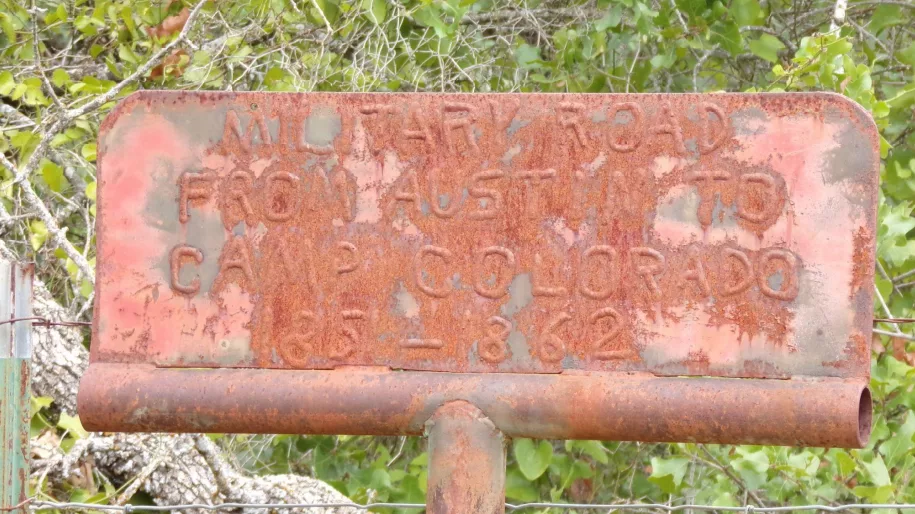
Along County Road 176, a few miles outside of Bangs, there is a largely hidden and slightly strange historical marker. The sign is old, and hard to see. It reads: ‘Military Road From Austin To Camp Colorado 1851 (I think that is a one) — 1862’. According to the sign, this little dirt road was once a portion of a military road out of Austin, and would have headed north to the frontier outpost of Camp Colorado.
Today, 176 is just a few miles of gravel top that loops around and comes back out on the highway. There is no way to tell for sure, as far as I could find by looking at old maps, if it really was a military road, but there is reason to suggest that it probably was something of that sort. Someone made the sign, and that person went through some trouble to do it. It’s not a state or county sign. It’s handmade, and you can see where someone welded it onto something like an old clothes line support post, or else made one similar for this purpose. The letters are not uniform, so I am guessing the person that made it sat and pounded out the shape of each letter by hand. It looks to be circa 1940 or so, although that is just a guess.
Bangs resident and local history buff Danny Marney, who runs Butter-beans Antiques in Early, remembered the marker and suggested I check it out. Danny described where he remembered seeing it, thinking it was gone now. I found that it’s not gone, but it is very hard to spot unless you’re really looking. Marney added that a few miles south of the location of the sign, there used to be a sandstone rock that was a memorial for a pioneer girl who died along this road. The rock has since fallen over, he stated, and the letters are worn off, but that at one time it told the story of how a migrating family stopped to bury their girl while traveling through the area.
My husband and I drove further down the road, looking for a rock that might be the one Danny talked about. I did see a sandstone boulder alongside the road that appears to have letters carved on it, but could only make out what seems to be the letter J. The story of the pioneer girl’s marker rock lends credence to the military road sign, as I doubt that any pioneer with a family coming through here at that time would wander off by themselves and neglect the safety of a route frequented by soldiers. Just down the Highway a few more miles is Santa Anna Mountain. Although Chief Santa Anna, whose tribe originally lived there, reportedly died in 1849, the mountain was still fiercely defended by the Penateka Comanche people. Settlers were traveling a notoriously dangerous route.
Old maps of the military roads in this area do not show any routes near Bangs. There was a military road that crossed the Colorado south of Trickham and went up to Camp Colorado circa 1855, and one east of Brownwood, established in 1851, that went northwest to Cross Plains. No doubt there was a turnoff on the Brownwood route heading to Camp Colorado, but it is not marked, although it seems to have passed through Thrifty, a good 15 miles north of the Bangs sign.
It’s possible the Bangs road was formed out of the Trickham military road, maybe to avoid trouble with the Comanche, or to circumvent flooded creeks or some other obstacle. I did not see any signs of a road continuing across the highway from County Road 176, but it would have been a long time ago, and things do change. Perhaps it ended at the highway and went either west or east to continue to the fort. I guess we might not find out, as it seems unlikely that anything has been written about this obscure little episode in history, but there’s always a chance someone out there might remember more about it.
***
Diane Adams is a local journalist whose columns appear Thursdays on BrownwoodNews.com
