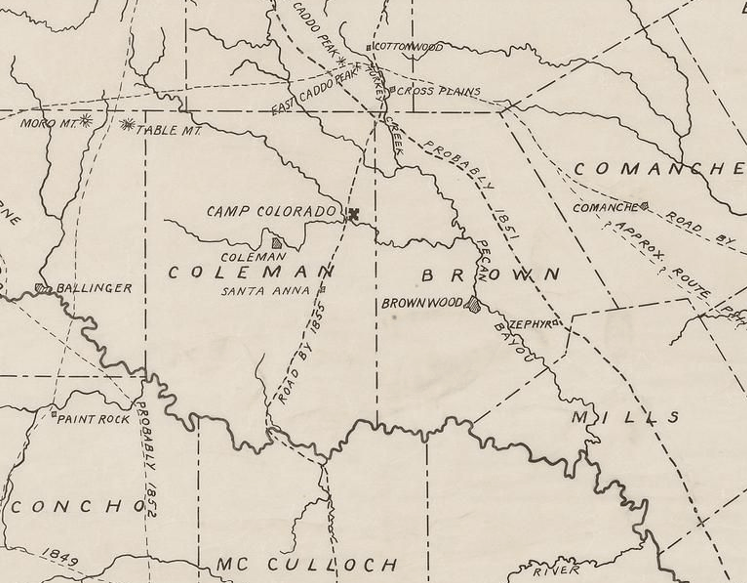
Somewhere along the banks of Mukewater Creek, between the ghost town of Trickham and the Colorado River, lies the lost ruins of the first Camp Colorado. A small military installation that was part of a chain of forts built during the mid 1800s to protect Anglo settlements along the edge of Comanche territory, the site was along the old military road that ran through what was then part of Brown County, now Coleman.
Camp Colorado was eventually moved to a location further north, along the Jim Ned Creek. The first camp did not last long, and today no one seems to know exactly where it was located. I set out to look into the issue, along with local researcher and Trickham history expert Don King, whose family has deep roots in the area, hoping to zero in on this forgotten piece of history.
From a passage from Ralph Terry’s book, A History of Coleman County and Its People, we learn: “‘Camp Colorado was established August 2nd, 1856, and is six miles North of the Colorado River of Texas on the road leading from Fort Mason to Fort Belknap,; according to the monthly Post Returns. This locale, which is about four miles from present day Trickham, proved to be temporary. Several of the soldiers, unaccustomed to the climate, contracted malaria, so in 1857, the camp was moved to a place twenty miles north on the Jim Ned Creek.”
Beatrice Gay tells a slightly different story in her chronicle of local history, Into the Setting Sun: “It is hard to determine just when the first little store was put down on Mukewater, but it was sometime during the late fifties, and most probably about the time Camp Colorado was established there. One authority tells us that ‘John Chisum started a little store down on Mukewater about a mile below the army post for the convenience of his trail drivers.’” So was it one mile from Trickham, or four? Let’s add some more accounts to the mix for good measure!
Also from Gay, in an article published by the Texas State Historical Association, we find this paragraph: “In 1855 Camp Colorado was probably temporarily at a site near what is now Ebony, in Mills County. In August 1856, Troops A and F of the United States Cavalry under Maj. Earl Van Dorn moved the camp to Mukewater Creek about six miles north of the Colorado River, on the route between Fort Belknap and Fort Mason in Coleman County. Because of sickness among the soldiers, the post was moved in July 1857 about twenty-two miles north to Jim Ned Creek.”
Leona Banister Bruce wrote on the topic in her book, Trickham, Texas a Neighborly Chronicle:“Brevet Major Earl van Dorn, a graduate of West Point and a distinguished veteran of the Mexican War, and Captain Theodore O’Hara, were in command of Companies A and F, and on July 29 they set out on the ride southward. They had three lieutenants and 119 men, several wagons of supplies, and nine prisoners in leg irons, soldiers being punished for fighting among themselves. The three officers rode on to the south, selecting a location for the proposed post on Mukewater Creek near the River.” That might place the location further south than Gay’s first account. It would make sense that the town of Trickham would spring up close to the outpost both for protection and supplies.
Don King pointed out a further complication that makes researching the early settlement of Trickham more difficult. “The name “Trickham” was not used until 1879 when the post office was approved, “ King said. “That means that between about 1857 and 1879 it was not referred to as Trickham. I suspect it was called “Mukewater”. Which can be kind of misleading unless it’s stated as something happened in “present-day Trickham” or some such. An event that happened in 1872 didn’t happen in Trickham.”
King thinks, and I suspect he’s correct, that the old military road likely ran through the early Camp Colorado site. Of course, nothing is going to be that easy, as Don points out: “At least one account says, as I’m sure you’re aware, that it was six miles up the military road from the Colorado River. There may have been two different routes for the Road. At least one map shows it further west near Whon and angling east toward Trickham, another map shows it crossing near Winchell and going due north toward Trickham.”
Was the site about one mile from Trickham? Maybe six miles up from, or even closer to, the river? We do know, from reliable sources, that the ruins of the first Camp Colorado were still visible in the late 1970s, and were located on what was described as a hunting ranch. It’s even possible that someone out there still knows where it was. Of course the site is bound to be on private property, but hopefully likely spots can be located and permission to search can be obtained. Who knows, maybe someday we can find it, record the information about its location and try to get a historical marker nearby, as I think it’s important to not lose track of historical sites like this one. Even if we don’t succeed in finding it this time around, it sure is fun trying!
***
Diane Adams is a local journalist whose columns appear Thursdays on BrownwoodNews.com
